UK Landmarks at Risk of Sea Level Rise
Sea Level Rise Puts UK's Most-Loved Landmarks at Risk
We have experienced warmer temperatures in the UK and other parts of Europe, which can be attributed to climate change. Factors such as thermal expansion, melting of glaciers, and human-emitted greenhouse gases all contribute to the rising temperatures, and consequently a rise in sea levels.
In efforts to show the urgency of sea level rise, GreenMatch analysed data published by Climate Central showing some of the most cherished landmarks that are at risk of sea level rise. This research evaluates the threat of sea level rise by 2050, as well as by the year 2100.
According to our findings, historical and cultural landmarks loved by generations are threatened from disappearing in 30 years time if temperatures continue to rise.
The global effort to fight climate crisis is the Paris Agreement deal, which states a clear goal to keep overall global temperatures way below 2°C above pre-industrial levels, and not exceed a temperature increase beyond 1.5°C by 2100. If we do not limit our carbon footprint and slow down the process of global warming, the path we are on now may lead to increase greater than 4°C by 2100, the Met Office warns.
Our planet is already 1°C warmer above pre-industrial levels and every further increase may affect sea level rise and endanger our landmarks. At GreenMatch, we found that London, South and East of England are particularly vulnerable to sea level rise.
Key findings of the study are:
- London and South East England: popular landmarks such as the London Eye, the Hampton Court Palace, the Brighton Palace Pier and the Needles on the Isle of Wight are significantly affected in both time frames 2050 and 2100.
- North West England: the Blackpool Tower is not likely to be threatened in the near future (2050), but it is at high risk by 2100.
- North East England: Lindisfarne will be affected by 2050, and according to the Climate Central the threat will be even more significant by 2100.
- Wales: Caernarfon Castle in Gwynedd is at risk of being impacted by sea level rise by 2050, with a severe threat by 2100.
The following elements were used to present this study:
Listed: 21 Landmarks Threatened by Rising Sea Levels
In the UK, a rise in sea level will impact coastal cities and flat, low altitude areas in the UK. The landmarks listed below are at risk of being affected. The study examines two time frames: 2050 and 2100.
The Tower of London

The Tower of London is a historic castle and royal palace located in central London by the north bank of the river. The tower that consists of several buildings secured by tall defence walls with a key significance for the English History. The tower was used as a prison, armoury, Royal Menagerie, and royal residence. The 900-year old castle is famous for housing the crown jewels.
The high risk scenario puts the London landmark at risk by 2050. Further damages attributed to sea level are likely to occur close to the tower, such as the destruction of the surrounding buildings, roads, and walking paths.
Major floods occurred in the River Thames in the previous century, and London is at risk of tidal surges and climate change that will put properties that are situated in close proximity to the river banks at risk.
London Eye

The London Eye is a Ferris wheel located on the River Thames. The construction is 443 feet high and has a diameter of 394 feet. The hub of the wheel stands on two supports, which are tied up to a foundation on the river.
The landmark that unravels scenic views from the top will very likely show a completely different picture. Our research showed that, in both 2050 and 2100, the landmark will be at serious threat of being destroyed.
As London lies in the ‘low-elevation coastal zone’, it is at risk of flooding. Thames Barrier, which is the main flood barrier for London, will be used more frequently as the vulnerability of rise in sea levels increase.
Hampton Court Palace

The Hampton Court Palace is a royal palace built upon Thames by Cardinal Thomas Wolsey, who was King Henry VIII’s advisor. Originally it was not meant to be a royal residence.
The Palace is surrounded by gardens like the famous Great Fountain Garden. There is also a famous maze called the Labyrinth, that was originally created in the late 17th Century.
Rising sea levels are affecting areas in London, especially residential and cultural buildings situated by the banks of the river. As global temperatures rise, London is said to be the most susceptible city to extreme windstorms, droughts, and floods.
Hampton Court Palace is another example of a historic landmark threatened by our changing climate as soon as the year 2050. Unfortunately, even further risk lays if sea levels are locked-in according to the highest-risk scenario in 2100.
Tower Bridge

The Tower Bridge is arguably one one of London’s most defining landmarks. It is a bascule and suspension bridge that crosses the River Thames. The bridge was built in the late 1800s and is 801 ft long. It consists of two towers with two walkways and it is visited and loved by many generations.
The Thames estuary is one of the UK’s primary flood risks. Research states that climate change will result in flooding from the North Sea and the River Thames. The landmark is already at risk of submersion by the year 2050.
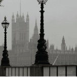
Palace of Westminster

The Palace of Westminster is a Victorian Gothic style palace, which is also called the House of Parliament. It is the palace where the House of Commons and the House of Lords meet. It is located on the North side of the River Thames.
The Westminster area is in danger of flooding, and our findings conclude that there is a risk for Britain's palace to be affected by 2050 and 2100.
Tate Modern
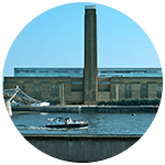
Tate Modern in London is located by the Bankside area in Southwark. With a large collection of modern and contemporary art, it is one of the largest galleries in the world, and along with its cultural significance for Britain’s national art, it is also a historic landmark.
The Tate Modern is situated right by the tidal river Thames, which connects the English Channel and the North Sea. Climate change may lead to more frequent flooding from the River Thames. Storm surges and high tides possess the biggest risk for London.
The capital may have a lot to lose as this landmark may be at risk of rising seas by 2050.
Jurassic Coast

The Jurassic Coast is situated on the English Channel Coast, South England. It features some of Britain’s most breathtaking rock formations stretches for 95 miles -- from East Devon to Dorset. Coastal erosion exposes continuous rock formations from different geologic periods and fossils.
Eight segments of the coast have been featured on the UNESCO’s World Heritage List that are eroding, and some are prone to landslides. With ongoing coastal erosion and a shift in the global climate, frequent storms and sea level rise threatens to change the picturesque landmark.
Increased levels of sea rise or deeper waters will likely put the present state of the Jurassic Coast at risk by the year 2050.
Brighton Palace Pier
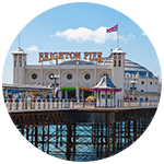
The Brighton Palace Pier is one of the oldest and finest piers in the UK. This Victorian pier is situated in the city centre and is 1,722 ft long. Originally, the pier was the old chain pier that was used in 1823 as a landing stage for passenger ships that came from France.
To this date, the pier experienced a lot of damage over the following years caused by multiple storms. In the future, high tide levels and heavy storm surges can lead to lower areas being at high risk for flooding.
According to our study, the iconic pier is at severe risk of raised sea levels both in 2050 and 2100.
The Needles, Isle of Wight
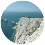
On the Isle of Wight there is a collective of three rocks called the Needles. The Isle of Wight has some military history: back in the Victorian times, the Needles battery provided coastal defence.
In 2005, the BBC labelled the Needles as one of the most important wonders of nature in the Southern part of England. The Isle of Wight has already been suffering a lot from coastal erosion and flooding for centuries. The rural beaches in the South of England are also receding.
The natural wonder is at severe risk caused by sea level rise, equally impacted in 2050 and 2100. Along with that, the present processes of erosion may be happening at a faster rate because of the future rising of the seas. This will have a further negative impact on the feature.
White Cliffs of Dover
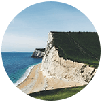
The White Cliffs of Dover are located on the Channel port in Kent. They are recognised as Britain’s official icon as they are considered a sign of security, inspiration, hope, and freedom. These cliffs are situated on the coastline, which is made of chalk.
The White Cliffs are continuously at risk of erosion and the cliffs shrink by roughly 1cm every year. The sharp edges can reach 350 feet above the sea level.
Sea level rise will affect the striking cliffs by 2050 already, but a more serious threat is posed in 2100.
Spinnaker Tower, Portsmouth

The Emirates Spinnaker Tower is a spectacular 170 metre tall landmark situated in the historic harbour of Portsmouth. The tower offers the best panoramic views of the South Coast.
Portsmouth's council raises awareness about the vulnerabilities of climate change for the coastal city, which is threatened by sea level rising. They note the likelihood of heat-related deaths and extreme weather events, such as storms and heavy rainfall.
The increase in sea level will threaten the landmark with the course we are on now as early as 2050.
Saint Michael’s Mount, Cornwall
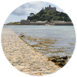
Saint Michael’s Mount is a tidal island in Mount’s Bay south-west England. Filled with rich history and legends, the small island takes visitors back in time with its history as a fortress, monastery, and family home of St Aubyn family since 1650.
The causeway that links the island with mainland Marazion is at risk of being submerged and destroyed by rising sea level. Observed beach lowering on the island may lead to exposure of cultural heritages to the seafloor and increase the threat of flooding.
That risk may be more evident if seas continue to rise and global temperature surpasses the 3°C mark. Our study showed that if that happens, the threat from increased sea level may be evident by 2050.
Humber Bridge
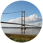
The Humber Bridge is a single-span suspension bridge connecting East of Yorkshire with North Lincolnshire. The bridge is only supported by two supports at the ends. The bridge stretches across the River Humber and is approximately 7,280 ft long.
According to the Committee on Climate Change, East Yorkshire is one of the English areas most vulnerable to coastal erosion. The extreme weather will result in more flooding, causing extreme sea level rises.
In 2050, the water may put the Humber Bridge at risk and further damages are projected by 2100.
Lindisfarne, Northumberland

Lindisfarne, or Holy Island, is known as one of the key centres of English Christianity. Situated off the Northumberland coast, North East of England, the beautiful island is linked by a causeway to the mainland.
At present, the causeway is covered by the tide twice a day. The powerful tides covering the causeway leave the island out to the sea and puts visitors at risk.
By the year 2050, there will likely be a negative impact on the land of Landisfarne, whilst projections for 2100 appeared to have affected most of the island.
Tyne Bridge, Newcastle & Gateshead
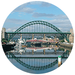
The Tyne Bridge is the bridge linking Newcastle upon Tyne and Gateshead. The towers of the bridge were built of cornish granite and are opened to the public as part of Heritage Open Days. Each year there is a Great North Run organised where 52,000 runners pass over the bridge.
According to our findings, the bridge may be destroyed by the effects of rising sea level already in the year 2050.
Blackpool Tower
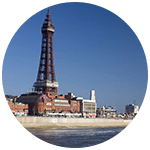
The Blackpool Tower is an observation tower built in 1894 in Lancashire, England. Inspired by the iconic Eiffel Tower, Blackpool Tower is equally stunning, at 518 feet above ground. It is marked as the 120th-tallest tower in the World and the tallest structure in the British empire.
Climate change and extreme weather events are threatening Blackpool’s three piers, which will affect the heritage structures and the seaside.
The Blackpool Tower will not be in danger in the near future (2050). However, our study shows that the beach-front landmark is at evident risk of rising sea level in 2100.
Windermere

Windermere is the largest natural ribbon lake in the Lake District and also in England. The lake is 10.5 miles long and 220 ft deep, and is surrounded by mountain peaks and villages. It was formed 13,000 years ago during the last major ice age. Windermere used to be a transport platform for stones, minerals, and animals.
Heavy rain will cause erosion to the ground. As a consequence, this will lead to dirt levels in the lakes.
Although reports show direct consequences of rising seas to be present but not severe, change in climate systems will impact the landscape. According to the projections for drier summers and wetter winters, flooding, droughts and other extreme weather conditions will affect the habitats.
Our study shows the landmark at risk that may affect the landmark and surrounding environments by 2050.
Royal Albert Dock, Liverpool
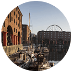
The Royal Albert Dock, located on the banks of the River Mersey, is Liverpool’s World Heritage Site waterfront. In the 19th century, the dock was used for global trade but it got closed to commercial traffic in the 1980s.
It is Britain’s first structure that was built without structural wood but with cast iron, brick, and stone. The Strand on the Meyerside could be hit hard by rising sea levels and storms, more powerful tides bringing in deep waters to the dockland may destroy it.
The dock is at risk under the high-risk scenario in the near 2050, with a likelihood of catastrophic damages in 2100.
Forth Bridge, East Lothian

The Forth Bridge, located in Scotland, is a railway bridge located that’s up to 8,296 feet long. It is recognised as the world’s first major steel structure and holds the record for the world’s longest cantilever bridge. It was labelled as the sixth World Heritage Site in Scotland by UNESCO in 2015.
According to the government assessments of the dangers of climate change, a lot of areas in Scotland are at risk from coastal erosion and flooding. Sea level will speed up the process and further affect the area.
Our study concluded that the Scottish gem will be at risk by 2050.
Ben Nevis

The highest and most majestic mountain on the British Isles, Ben Nevis, is located in the Scottish Highlands. Once a former volcano, Scotland’s landmark offers walking and climbing trails for those seeking adventures in nature.
Milder winters and decreased snowfall will likely affect the surrounding flora and habitat. The sea level rise in the Highland area is at a greater rate than the rebound since the last ice age.
Weather variations impacted by climate change put the current face of this environmental and cultural landscape at risk. Although the peak may not be directly affected, climate change and its associated impacts will threaten the land below it.
In 2100, there is a higher risk for the landmark in comparison with 2050.
Caernarfon Castle, Gwynedd
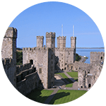
Located on the north bank of the River Seiont, Caernarfon Castle is a medieval fortress in Gwynedd, Wales. It is a World Heritage Site, which is also globally granted as one of the greatest buildings of the Middle Ages. One part of the building is a castle and the other half is a royal palace.
Gwynedd was established a century ago, which means that the first properties were built on land reclaimed from the sea. These properties are only just above sea levels, putting the landmark at severe risk from increasing rising sea levels by the year 2100.
Adaptation to Climate Change
Even if the temperatures are stabilised to up to 1.5°C, we are still at evident risk of losing key cultural landmarks and places we love at present. Many landmarks will still be threatened by the effects of climate change and might not exist for future generations to visit.
Since no matter what we do, we are polluting the atmosphere, and personal efforts are equally important as governmental targets. We need to mitigate and adapt to the resulting changes in climate.
Increased energy efficiency, more widespread adoption of the idea of using renewable energy in your home. In the UK, 30% of total electricity generated was by renewables.
In addition, government grants, such as the Renewable Heat Incentive and various solar panel grants, encourage homeowners to invest in renewables.
Steps in this direction will help reduce the overall levels of harmful pollutants, such as greenhouse gases.
Methodology
The British landmarks that were assessed were based on the list provided by Loveexploring.com, which was published in 2018.
In order to evaluate the risk of sea level rise, these landmarks were evaluated in relation to data published by Climate Central. Their Surging Seas Map, which illustrates the sea level timing projections.
Climate Central bases their sea level projections on two time periods - 2050 and 2100. They compare sea level rise based on different pathways of carbon dioxide emissions and the resulting atmospheric concentration. We examined a high-risk scenario, referred to from Climate Central as ‘the unchecked pollution’.
Unchecked pollution scenario, also referred as RCP 8.5, implies that we will emit a total of 2,430 gigatonnes of carbon by 2100. This will correspond to a warming of 3.3°C and a 7.1 metre rise in global sea level.
In this scenario, annual emissions are still increasing in 2100, meaning locked-in sea levels will continue to rise. However, the Surging Seas map doesn’t illustrate further projections past the year 2100.
Dataset
The following sources were used to compile this study:
| Data | Source |
|---|---|
| Sea level rise | Climate Central's Surging Seas Map |
| Love Exploring | UK Landmarks |
| Climate change | Case Study on Climate Change and World Heritage |
| Impacts of Climate Change in the UK | |
| Coastal erosion and flooding | Coastal Erosion on Heritage UK Properties |
| UK Flooding Risk in Coastal Areas | |
| Regional reports | South East River Flood Management |
| London Area | |
| Jurassic Coast | |
| Saint Michael's Mount | |
| Northumberland |


We strive to connect our customers with the right product and supplier. Would you like to be part of GreenMatch?
